


Rémalard 17.11

togolo28
User
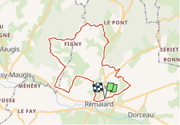

Length
17.2 km

Max alt
242 m

Uphill gradient
314 m
Km-Effort
21 km

Min alt
125 m

Downhill gradient
314 m
Boucle
Yes
Creation date :
2018-04-09 00:00:00.0
Updated on :
2020-07-05 19:07:45.121
4h36
Difficulty : Medium

FREE GPS app for hiking
 SityTrail
IGN / Geographical institutes
SityTrail Plus
The world is yours!
About
Trail Walking of 17.2 km to be discovered at Normandy, Orne, Rémalard en Perche. This trail is proposed by togolo28.
Positioning
Country:
France
Region :
Normandy
Department/Province :
Orne
Municipality :
Rémalard en Perche
Location:
Rémalard
Start:(Dec)
Start:(UTM)
335659 ; 5366511 (31U) N.
Comments
Superbe randonnée, nombreux et beaux chemins creux